
Tennessee
Stewart County
6.3
Acre +/-
Acres +/-
Sold
Pending sale
$
$
99997
99997
USD
Price
To Be Determined


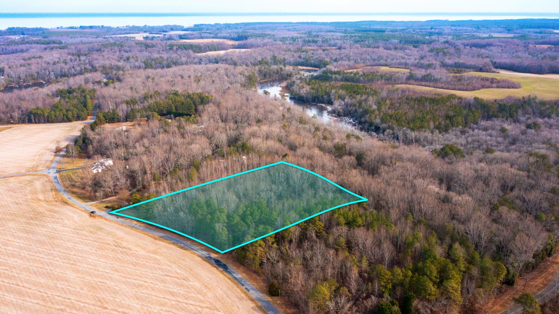
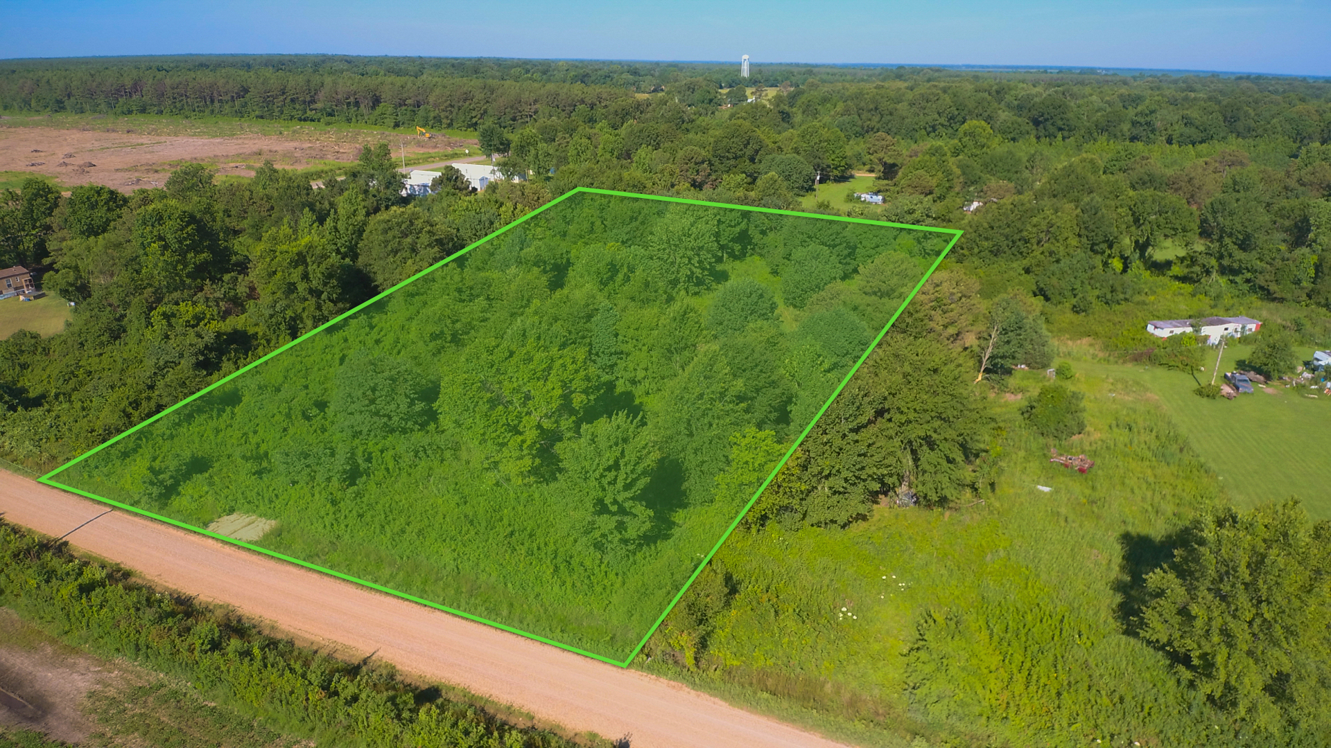
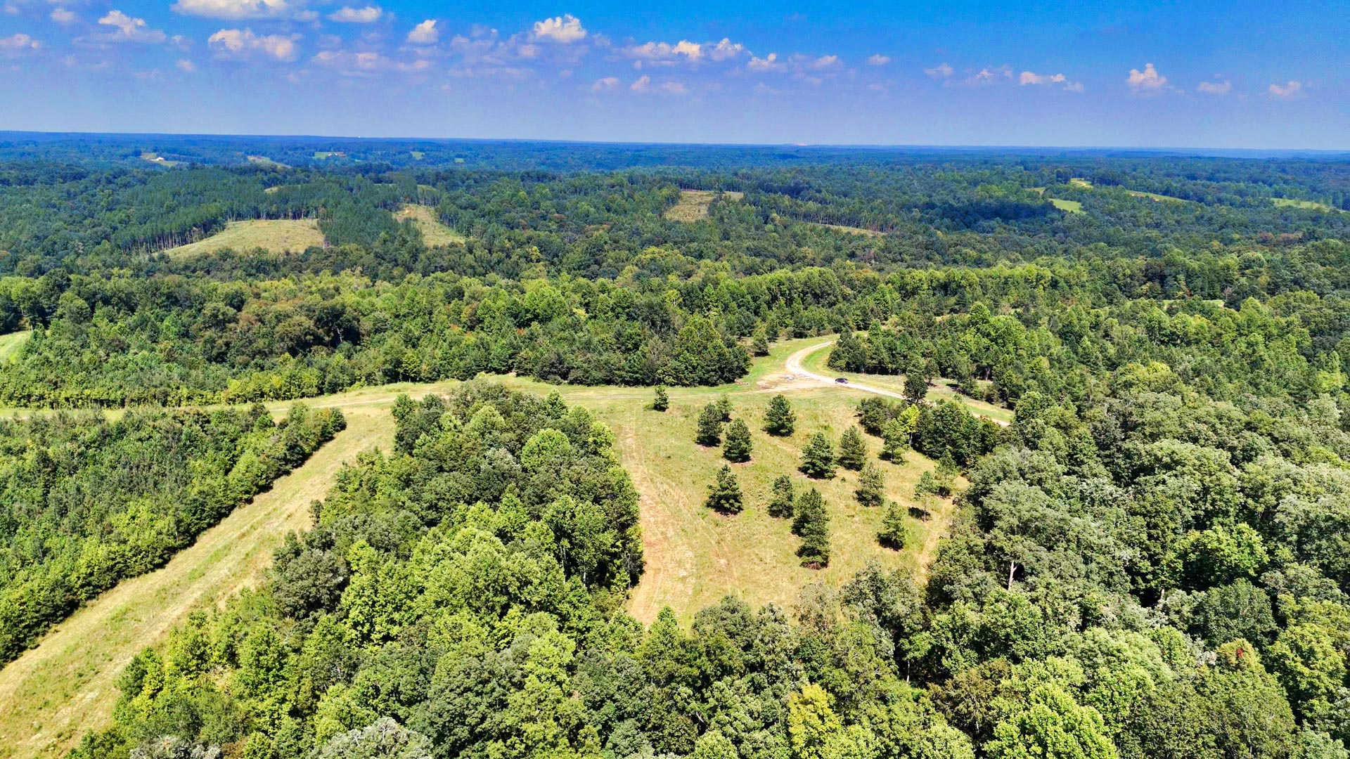
6.3 Wooded Acres with Road Access, Power & High-Speed Fiber Internet
FREEDOM RIDGE OVERVIEW
LOT 23 VIRTUAL TOUR
Loading
Loading


LANDIO ID
TN_Stewart_00023
Tennessee
Stewart County
6.3
Acre +/-
Acres +/-
Sold
Pending sale
$
$
99997
99997
USD
USD
Price
To Be Determined
$499 deposit secures this property
Price
To Be Determined
The Sale of This Property is Currently PENDING.
Check Out the AVAILABLE Properties
Price
To Be Determined
🚀 VIEW BROCHURE 🤠 SCHEDULE TOUR
For Questions or To Purchase This Property, Please Call or Text LANDIO Anytime at: 866-8-LANDIO (866-852-6346)
For Questions or To Purchase This Property, Please Call or Text Mark Huber with the FREEDOM RIDGE Team Anytime at: 615-375-0245
You may also Email Mark at: hello@freedomridge.com
Please Reference: FREEDOM RIDGE Lot 23
This Property is 1 of 42 Tracts being offered in FREEDOM RIDGE. Several of the Lots are Already PENDING Sales.
The following Subdivision Map shows the Status of Each Lot with Links to View the Property Details Page of the Lot.
Green = AVAILABLE, Purple = PENDING, Red = SOLD
View the Interactive Map showing ALL 42 Lots
To Speak with LANDIO, Call or Text Us Anytime at 866-8-LANDIO (866-852-6346)
Property to SELL? Visit: SELLwithLANDIO.com
Are You an Agent or Broker in Need of More Exposure for Your Listings? Visit: GOLANDIO.com
Property Specs
Property Description
🚀 VIEW BROCHURE 🤠 SCHEDULE TOUR
FREEDOM RIDGE
Imagine waking up to birds chirping in the trees and the sun peeking over the rolling hills of Northern Tennessee. This spacious subdivision in Stewart County near Clarksville, TN, has it all—wildflower meadows, mature hardwood forests, and towering pines for year-round beauty.
With NO HOA, Covenants or Restrictions, FREEDOM RIDGE feels like home in nature. Connect with the Land, Your Inner Self and Those You Love. This gently-developed subdivision supplies privacy and showcases the natural landscape, while still providing access to modern amenities.
More Freedom & Land Opportunities
Nothing beats living with the Land. As the name suggests, FREEDOM RIDGE creates the Opportunity for you to fully express your Land Dreams. Build a Custom Home, a Tiny Home, Live in an RV or use the Property Recreationally.
From traditional custom homes to alternative living, working, and recreational spaces (yurt, guesthouse, studio, tiny home, container home, RV, tent, cabin, vacation rental, etc.), you have ample room to dream and design. Or, simply keep it as-is to enjoy and put some of your wealth into the ground.
Livestock, hunting & fishing (with a license), ATVs, camping, horseback riding, and farming are all possible at FREEDOM RIDGE.
Deer Haven Road is the main road that provides access throughout the subdivision. Some interior roads are in the process of being created.
Hunting & Fishing
Whether on your own property or a nearby public hunting area, Northern Tennessee is an excellent region for seasonal game hunting of whitetail deer and wild turkey. Find hunting locations and license/permit info here.
The subdivision is just 5 miles from the Cross Creek NWR Boat Ramp. The creek feeds into the 688 mile historic Cumberland River that has long supported riverboat trade and travel. Today, it draws many hunters, anglers, and outdoor enthusiasts to its thriving waters and banks.
Massive striped bass, rainbow and brown trout, walleye, sauger, and catfish flourish within the river. Clarksville is another recreational access point along the Cumberland River. Find fishing tips and Clarksville Marina info here.
FREEDOM RIDGE is also 40 minutes from Kentucky Lake, which winds along the Tennessee River. Kentucky Lake is known for trophy-winning largemouth bass, bluegill, redear, crappie, and catfish. Get more info on Kentucky Lake fishing here.
Outdoor Recreation
If you’re yearning for more adventure away from home, Kentucky Lake, Land Between the Lakes (LBL), and Lake Barkley are all less than an hour from the subdivision and provide thousands of acres of land and water to play, relax, camp, boat, hike, and more. Book a guide or plan your own adventure. Learn more about Tennessee’s best outdoor recreational gems here.
Necessities & Places to Visit
For necessities, Indian Mound is just a few minutes away, which has a post office, grocery stores/food market, restaurants, churches, schools, and professional services.
About a 30 minute drive from FREEDOM RIDGE, Clarksville has all the modern amenities, resources and supplies that a family needs, while maintaining a sense of small-town charm.
Clarksville has a population of around 170,000. In Clarksville you will find a Hospital, Home Depot, Lowes, Sam’s Club, Walmart, Grocery Stores, Restaurants and Professional Services.
Fort Campbell is 29 miles from the FREEDOM RIDGE and is home to the 101st Airborne. Fort Campbell Supports the 4th Largest Military Population in the Army (and the 7th Largest in the Department of Defense).
The Cumberland River is the heartbeat of this historic town. Stroll along the River Walk, attend a concert at Dunbar Cave State Park, float the Clarksville Blueway, enjoy over 20 miles of walking and biking paths, visit the Farmer’s Market, or learn about the town’s rich history. In addition to modern retailers and amenities, Clarksville has a vibrant arts and museum district and charming downtown. From pizzerias and breweries to steakhouses and bakeries, Clarksville is well worth the trip. Get to know Clarksville here.
Utilities
Power is at the Property along the Road
High-Speed Fiber Optic Internet is at the Property along the Road
Multiple Water Wells have been successfully drilled on Lots in FREEDOM RIDGE. The cost for drilling the Water Well ranges from around $11k - $15k. Please Contact Us for a list of Licensed Water Well Contractors. Alternatively you would haul water to store in a cistern. If using the property recreationally, you could bring your own water as needed.
This Lot has passed the Perc Test needed for the Septic Permit and Installation. A Septic System or Alternative Solution will need to be installed if developing the Property. Please Contact Us for a list of Licensed Septic Contractors.
Property Specifications
LANDIO Property ID: TN_Stewart_00023
Parcel Size: 6.3 Acres M/L
Legal Description: FREEDOM RIDGE Lot 23
Property Taxes: $630 per year
HOA Fee: None
Title: Free & Clear
Conveyance: Warranty Deed
Approximate Distance to Nearby Cities & Points of Interest
4 miles to Indian Mound, TN (more info)
5.6 miles to Cross Creek NWR Boat Ramp (more info)
20 miles to Dover, TN : Population 1,825 (more info)
26 miles to Clarksville, TN : Population 167,000 (more info)
26 miles to Land Between the Lakes National Recreation Area (more info)
29 miles to Cross Creeks National Wildlife Refuge (more info)
26 miles to Clarksville, TN : Population 167,000 (more info)
29 miles to Fort Campbell (more info)
29 miles to Cross Creeks National Wildlife Refuge (more info)
29 miles to Stewart State Forest (more info)
36 miles to Kentucky Lake (more info)
48 miles to Hopkinsville, KY : Population 31,000 (more info)
77 miles to Nashville, TN : Population 2,000,000 (more info)
86 miles to Natchez Trace State Park (more info)
113 miles to Jackson, TN : Population 68,200 (more info)
189 miles to Memphis, TN : Population 633,000 (more info)
Visiting the Property
To Visit this Property, Please SCHEDULE A TOUR or Contact the FREEDOM RIDGE Team Anytime by Call or Text at: 615-375-0245
Interactive Map of Lot 23 (View Map)
Interactive Map of All 42 Lots in FREEDOM RIDGE, Green = AVAILABLE, Purple = PENDING, Red = SOLD (View Map)
GPS Coordinates
Northwest Corner: 36.4713513710123, -87.6584151726108 (Google Map)
Northeast Corner: 36.4709313617697, -87.65766039047119 (Google Map)
Southeast Corner: 36.4691351167288, -87.6591254363225 (Google Map)
Southwest Corner: 36.4701618414095, -87.6599994868096 (Google Map)
Center Point: 36.470329, -87.658854 (Google Map)
Contact Info
For Questions or To Purchase This Property, Please Call or Text Mark Huber with the FREEDOM RIDGE Team Anytime at: 615-375-0245
You may also Email Mark at: hello@freedomridge.com
Please Reference: FREEDOM RIDGE Lot 23
This Property is 1 of 42 Tracts being offered in FREEDOM RIDGE. Several of the Lots are Already PENDING Sales.
The following Subdivision Map shows the Status of Each Lot with Links to View the Property Details Page of the Lot.
Green = AVAILABLE, Purple = PENDING, Red = SOLD
View the Interactive Map showing ALL 42 Lots
To Speak with LANDIO, Call or Text Us Anytime at 866-8-LANDIO (866-852-6346)
Property to SELL? Visit: SELLwithLANDIO.com
Are You an Agent or Broker in Need of More Exposure for Your Listings? Visit: GOLANDIO.com
Property Description
20 Wooded Mountain Acres bordering nearly 300,000 Acres of the Cibola National Forest less than 1 mile from "The Falls" waterfall.
This parcel borders the Cibola National Forest along the West boundary and is covered with dense mature Ponderosa Pines.
There is seasonal water flow running through the entire Eastern portion of the property.
This beautiful forest property offers varying terrain, with the peak elevation on the Western portion near the Cibola National Forest reaching 7,640 feet. This is among one of the highest points in the area, comparable with the 7,700 foot Mesa located 4 miles South.
Bordering the Cibola National Forest comes with opportunity for extended recreation right from the property. The seasonal water flow also offers a source of water for the wildlife residing in the forest. See photos for the many wildlife tracks & droppings found on the property.
Located in Game Management Unit 10, which is said to be desirable for Mule Deer & Elk with some of largest Bulls in New Mexico. (Download the GMU 10 Map)
For more information, visit the New Mexico Game & Fish Department Website.
The richly diverse volcanic landscape of El Malpais National Park offers solitude, recreation, and discovery. Explore cinder cones, lava tube caves, sandstone bluffs, caves and hiking trails. Wildlife abounds in the open grasslands and forests.
The property is 8.7 miles to State Highway 53 which will take you directly to San Rafael to the East, then connects to I-40 to take you into Grants and Milan.
The city of Gallup is located 52 miles from the property. There is a Walmart Supercenter, various parks, professional services, medical centers, groceries, and supplies located here. The population of Gallup, New Mexico is about 21,700.
Grants, New Mexico is also located only 61 miles East, which has a population of around 10,000 people. In Grants you will find groceries, supplies, the Cibola General Hospital, an airport and Walmart Supercenter.
Utility Lines are in the area and on nearby developed properties where land owners have homes, mobile homes, cabins, accessory buildings and corrals (see photos & satellite images).
No HOA, HOA Fees, or time limit to build.
Property Specs
🚀 VIEW BROCHURE 🤠 SCHEDULE TOUR
For Questions or To Purchase This Property, Please Call or Text LANDIO Anytime at: 866-8-LANDIO (866-852-6346)
For Questions or To Purchase This Property, Please Call or Text Mark Huber with the FREEDOM RIDGE Team Anytime at: 615-375-0245
You may also Email Mark at: hello@freedomridge.com
Please Reference: FREEDOM RIDGE Lot 23
This Property is 1 of 42 Tracts being offered in FREEDOM RIDGE. Several of the Lots are Already PENDING Sales.
The following Subdivision Map shows the Status of Each Lot with Links to View the Property Details Page of the Lot.
Green = AVAILABLE, Purple = PENDING, Red = SOLD
View the Interactive Map showing ALL 42 Lots
To Speak with LANDIO, Call or Text Us Anytime at 866-8-LANDIO (866-852-6346)
Property to SELL? Visit: SELLwithLANDIO.com
Are You an Agent or Broker in Need of More Exposure for Your Listings? Visit: GOLANDIO.com
Nearby Points of Interest
Bordering the Cibola National Forest (more info)
0.27 mile to Ramah Falls (more info)
8.7 miles to Highway 53
19 miles to El Morro National Monument (more info)
33.1 miles to the El Malpais National Monument (more info)
33.6 miles to the Oso Ridge Lookout (more info)
35.4 miles to the Ice Cave and Bandera Volcano (more info)
52.5 miles to Gallup, New Mexico : Population 21,700 (more info)
56.7 miles to San Rafael, New Mexico : Population 1,000
58.6 miles to the Bluewater State Park (more info)
60 miles to Interstate 40
61 miles to Grants, New Mexico: Population 10,000 (more info)
61.5 miles to Milan, New Mexico : Population 3,200 (more info)
82.5 miles to the Mount Taylor (more info)
137 miles to Albuquerque, New Mexico : Population 556,000 (more info)
Location Information
To Visit This Property, Please Call the Listing Agent Paul Linson at: at: 505-907-1454
The Interactive Maps are generated with MapRight. MapRight has a Free Apple and Android App which can be useful when visiting a property. Below are links to download the Free MapRight App.
Apple (Download App)
Android (Download App)
Interactive Map (View Map)
GPS Coordinates
Northwest Corner: 35.2112301717262, -108.451841649108 (Google Map)
Northeast Corner: 35.2112121367072, -108.447455305649 (Google Map)
Southeast Corner: 35.2095039461638, -108.447431024468 (Google Map)
Southwest Corner: 35.2095218936116, -108.451796661172 (Google Map)
Center Point: 35.210329, -108.449735 (Google Map)
Contact Information
This Property is Listed with New Mexico Real Estate Broker Paul Linson of The Pedroncelli Group Realtors.
If you are interested in Purchasing this Property or any other Property in New Mexico, please contact Paul by Call or Text anytime at: 505-907-1454
Please Reference LANDIO Property ID: NM_Cibola_00066
To Speak with LANDIO, please Call or Text Us Anytime at 866-8-LANDIO (866-852-6346))
Do You Have Property to SELL? Visit at: SELLwithLANDIO.com
Buying Process
Sell Your Property
Questions About This Property?
Contact UsNearby Properties
North Carolina
NC_Caldwell_00001

4.88 Acres with Power, Internet & Road Access near Pisgah National Forest
Tennessee
TN_Stewart_00008

3.2 Wooded Acres with Road Access, Power & High-Speed Fiber Internet
Tennessee
TN_Stewart_00009

2.9 Wooded Acres with Road Access, Power & High-Speed Fiber Internet
Tennessee
TN_Stewart_00010

3 Wooded Acres with Road Access, Power & High-Speed Fiber Internet
New Mexico
NM_Cibola_00071

5.03 Acres with Road Frontage near Cibola National Forest
West Virginia
WV_Ritchie_00001

4.61 Wooded Acres with County Road Frontage
Georgia
GA_Warren_00001

7.59 Wooded Acres with Power & Road Frontage
Tennessee
TN_Stewart_00038

3.5 Wooded Acres with Road Access, Power & High-Speed Fiber Internet
Virginia
VA_Northumberland_00002

2.25 Acres Waterfront Lot that Connects to the Potomac River & Chesapeake Bay
Illinois
IL_McLean_00002

405 Acre Income Producing Farm with Power & County Road Frontage
New Mexico
NM_Cibola_00072

20 Acres on top of Mesa with Road Access, Mature Trees & Power Nearby
Virginia
VA_Northumberland_00001
5.5 Acres near the Potomac River & Chesapeake Bay
Illinois
IL_McLean_00003

380 Acre Income Producing Farm with Power & County Road Frontage
Wyoming
WY_Carbon_00057

2.05 Acre Lot with Mountain Views near National Forest
Wyoming
WY_Sweetwater_00025

80 Acres bordering 640 Acres of BLM Land around Wild Horses
Arkansas
AR_Chicot_00001
1.94 Acres with Road Frontage & Electricity near the Mississippi River
Wyoming
WY_Natrona_00006

561 Acres bordering BLM Land Overlooking the Alcova Reservoir
New Mexico
NM_Cibola_00074

16 Wooded Mountain Acres near National Forest Land
New Mexico
NM_Lincoln_00004

78 Acre Farm with Water Rights, Power & County Road Frontage
Colorado
CO_Otero_00001

1.38 Acres with 3 Bedroom Home, Workshop & Storefront
New Mexico
NM_Cibola_00040

20 Acres with Private Access to the Cibola National Forest
Colorado
CO_Conejos_00023

433 Acre Riverfront Farm & Ranch with Senior Water Rights & 6 Bedroom Home
Colorado
CO_Las-Animas_00054

35 Wooded Mountain Acres with Electricity & Clearing for Homesite
Florida
FL_Washington_00001

Wooded Acreage with Power & Paved Road Frontage near The Gulf Coast
Wyoming
WY_Sweetwater_00028

120 Acres with Access Bordering BLM Land
New Mexico
NM_Cibola_00066

20 Wooded Mountain Acres Bordering National Forest Land
Colorado
CO_Costilla_00015
2.7 Acres with Mountain Views near Sanchez Reservoir State Wildlife Area
New Mexico
NM_San-Miguel_00002

543 Acres bordering 25,000 Acres of National Forest Land
Utah
UT_Iron_00001

640 Acres bordering BLM Land near Fishlake National Forest
New Mexico
NM_Torrance_00006

10.04 Acres with Power, Internet & Access near National Forest
Montana
MT_Lake_00001

Moiese Valley Ranch | 2,425 Acre Montana Ranch & Dairy Farm
Tennessee
TN_Stewart_00003

4.3 Wooded Acres with Road Access, Power & High-Speed Fiber Internet
Tennessee
TN_Stewart_00004

4.2 Wooded Acres with Road Access, Power & High-Speed Fiber Internet
Tennessee
TN_Stewart_00006

5.2 Wooded Acres with Road Access, Power & High-Speed Fiber Internet
Tennessee
TN_Stewart_00007

4 Wooded Acres with Water Well, Road Access, Power & High-Speed Fiber Internet
Tennessee
TN_Stewart_00017

3.4 Wooded Acres with Road Access, Power & High-Speed Fiber Internet
Tennessee
TN_Stewart_00021
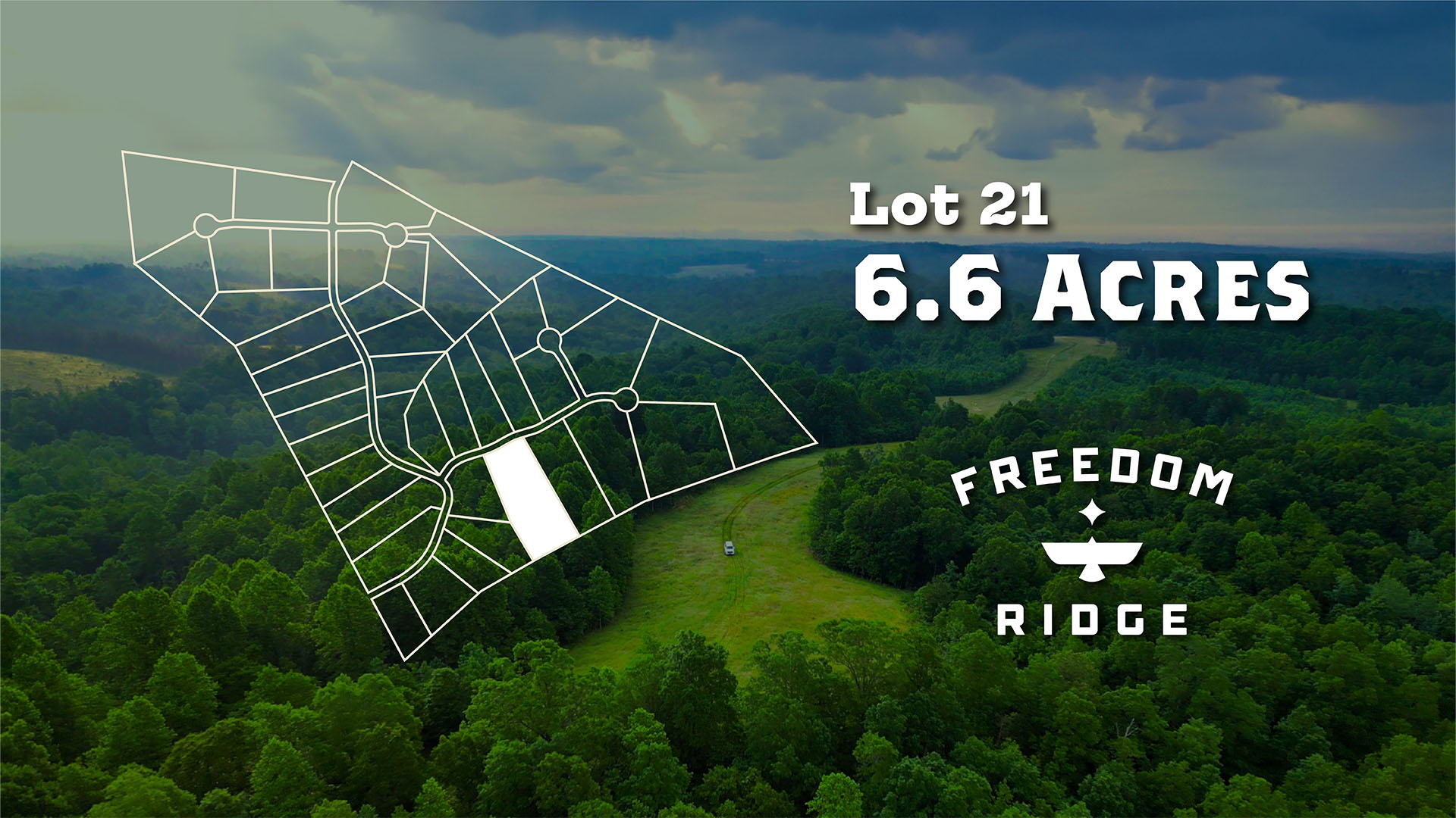
6.6 Wooded Acres with Road Access, Power & High-Speed Fiber Internet
Tennessee
TN_Stewart_00022

5.4 Wooded Acres with Road Access, Power & High-Speed Fiber Internet
Tennessee
TN_Stewart_00023

6.3 Wooded Acres with Road Access, Power & High-Speed Fiber Internet
Tennessee
TN_Stewart_00024

8.5 Wooded Acres near the Cumberland River & Clarksville, TN
Tennessee
TN_Stewart_00025

13.8 Wooded Acres near the Cumberland River & Clarksville, TN
Tennessee
TN_Stewart_00027

3.5 Wooded Acres with Road Access, Power & High-Speed Fiber Internet
Tennessee
TN_Stewart_00028

3 Wooded Acres with Road Access, Power & High-Speed Fiber Internet
Tennessee
TN_Stewart_00030

4.1 Wooded Acres with Water Well, Road Access, Power & High-Speed Fiber Internet
Tennessee
TN_Stewart_00031

3.8 Wooded Acres with Road Access, Power & High-Speed Fiber Internet
Tennessee
TN_Stewart_00032
3.1 Wooded Acres with Road Access, Power & High-Speed Fiber Internet
Tennessee
TN_Stewart_00034

2.4 Wooded Acres with Road Access, Power & High-Speed Fiber Internet
Tennessee
TN_Stewart_00037

2.5 Wooded Acres with Road Access, Power & High-Speed Fiber Internet
Tennessee
TN_Stewart_00040

5.1 Wooded Acres with Road Access, Power & High-Speed Fiber Internet
Tennessee
TN_Stewart_00041

5.4 Wooded Acres with Road Access, Power & High-Speed Fiber Internet
New Mexico
NM_Torrance_00018

10.32 Acre Corner Lot with Power & Internet near National Forest
Utah
UT_Iron_00002

23.52 Acres bordering BLM Land near Fishlake National Forest
Washington
WA_Clark_00002

5 Wooded Acres with Creek, Power & Water near National Forest
Wyoming
WY_Natrona_00005

174 Acres with Creek overlooking the Alcova Reservoir
New York
NY_Putnam_00001

112 Acres across from West Branch Reservoir & Bordering Public Land
Wyoming
WY_Natrona_00004

6 Acres with Road Frontage bordering BLM Land near Alcova Reservoir
Illinois
IL_McLean_00001

786 Acre Income Producing Farm with Power & County Road Frontage
California
CA_San-Bernardino_00002

4.37 Acres Surrounded by National Forest near Big Bear Lake
New Mexico
NM_Sandoval_00001

11.49 Acres with Road Frontage, Electricity near BLM Land
California
CA_Inyo_00011

0.87 Acres with Mountain Views near Inyo National Forest
California
CA_Inyo_00010

0.83 Acres with Mountain Views near Inyo National Forest
California
CA_Inyo_00006

0.98 Acres with Mountain Views near Inyo National Forest
California
CA_San-Bernardino_00001

1 Acre with Mountain Views near San Bernardino National Forest
New Mexico
NM_Torrance_00017

10.34 Acres with Power, Internet & Access near National Forest
New Mexico
NM_Torrance_00013

10.03 Acres with Power, Internet & Access near National Forest
New Mexico
NM_Torrance_00007

10.35 Acres with Power, Internet & Access near National Forest
New Mexico
NM_Torrance_00003

10.73 Acres with Power, Internet & Access near National Forest
New Mexico
NM_Torrance_00014


