
West Virginia
Ritchie County
9.01
Acre +/-
Acres +/-
Sold
Pending sale
$
$
24997
24997
USD
Price
To Be Determined


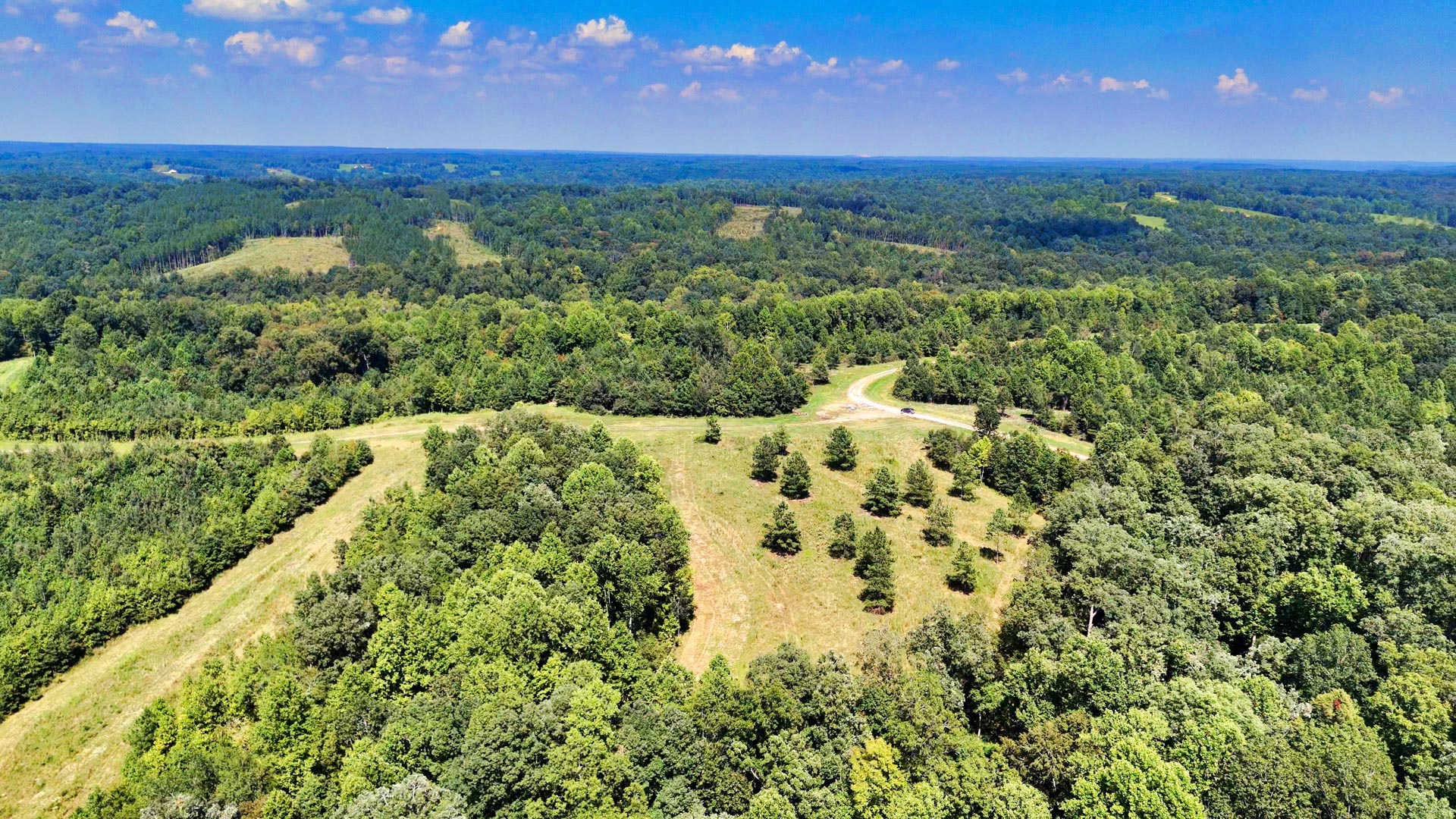
9.01 Wooded Acres with County Road Frontage
Loading
Loading


LANDIO ID
WV_Ritchie_00002
West Virginia
Ritchie County
9.01
Acre +/-
Acres +/-
Sold
Pending sale
$
$
24997
24997
USD
USD
Price
To Be Determined
$499 deposit secures this property
Price
To Be Determined
The Sale of This Property is Currently PENDING.
Check Out the AVAILABLE Properties
Price
To Be Determined
Click the Green BUY NOW Button to place your $499 Deposit. We will receive an instant notification that your $499 deposit has been made. The $499 deposit is credited towards your purchase and we cover ALL of the Closing Costs.
The remaining balance may be paid by Wire Transfer, Cashier’s Check, ACH Bank Draft, Credit Card and/or Debit Card. We also accept Gold, Silver, Platinum, Bitcoin, Ethereum and other Cryptocurrencies. You may also use any combination of these payment methods.
We make the whole process super simple and we can complete your purchase in as little as 1 day.
Purchase Must Be Completed within 10 Calendar Days of the Date the Deposit is placed. A partial refund of $250 may be requested within 5 Calendar Days from the date of the deposit. After the 5th Calendar Day, all cancelled purchases will not be eligible for a refund.
For Questions or to Purchase this Property, Call or Text Us anytime at 866-8-LANDIO (866-852-6346)
Reference LANDIO Property ID: WV_Ritchie_00002
*This Property is presented For Sale By Owner. Seller is a Licensed Real Estate Agent in the State of Texas.
Are You an Agent or Broker in Need of More Exposure for Your Listings? Visit: GOLANDIO.com
Property to Sell? Visit: SELLwithLANDIO.com
Property Specs
Property Description
Discover heaven among the tree-covered hills and grassy valleys of West Virginia’s breathtaking Heartland Region. This wooded 9.01 Acre parcel is primely located nearthe flowing Hughes River and around the corner from the historic North Bend Rail Trail and North Bend State Park.
“Wild and Wonderful” certainly applies to this beautiful Appalachian parcel. Ritchie Mines Wildlife Management Area and Hughes WMA provide endless opportunities for adventure, wildlife watching, hunting, and fishing. White-tailed deer, black bear, bobcat, turkey, grouse, and other small game call this pine-studded haven home. Ritchie is a favorite location for avid hunters and outdoor enthusiasts.
(If you’re a history buff, you can learn more here about this historic area and Ritchie Mines where natural asphalt was discovered.)
With diverse tree coverage and minimal undergrowth, this versatile property is ideal for a small farm, homestead, hunting cabin, vacation property, or off-grid living. With no HOA, you’re free to make it your own. Manufactured homes, tiny homes, recreational vehicles, and camping are permitted.
Accessibility & Utilities
This parcel is primed and ready for your vision. It has well water, gas, and underground telephone lines at neighboring properties.
Frontage along Oil Ridge Road (CR 26) makes it easy to hop onto Hwy 31 to head to Hughes River or into Cairo. (The North Bend Trail Head is in Cairo.) In the spring and summer, this small town lives up to its name and is as lush as the Egyptian city along the Nile.
In addition to the locally run Cairo Meat & Grocery, a gas station, bank, bike rental, and a few other necessities, Cairo showcases a rich history with buildings and architecture dating back to the oil boom.
Local Attractions & Outdoor Activities
The historic tree-lined 72-mile Rail Trail runs from Parkersburg to Wolf Summit. The 3.8-mile portion from Cairo to North Bend State Park is perfect for hikers and cyclists who want to experience several of the trail’s 48 historic railroad tunnels, bridges, and stations. (View trail info here.) You can even stop and stay awhile at the State Park, which has a restaurant, cabins, lodges, and camping sites.
The 111-mile Hughes River is simply stunning and ever-changing. Some portions meander through wildflower valleys and pastures, while others rush beneath towering sycamore and lush forests. No matter which path you take, you’re sure to be in for an unforgettable experience with trophy-sized muskie, catfish, several species of bass, and a variety of sunfish.
Mountwood Park, a historic oil boomtown site, is a favorite recreation area for locals and visitors alike. The scenic park featuring a glistening 50 acre lake has just about everything: newly remodeled lodging and lakeshore cabins, an ATV park, 50 miles of hiking & biking trails, a museum, a dog park, and more! Their seasonal events like Volcano Days and the Fishing Derby are always fun!
Nearby Towns & Cities
Harrisville is just 10 miles away, and it has a regional medical center, public schools, parks, professional services, grocers, retailers, and eateries.
Parkersburg is the nearest large city, about 33 miles northwest along the WV/Ohio line. It has everything from robust medical centers to Dunkin Donuts and the sprawling WVU at Parkersburg campus.
No matter what’s calling you into wild and wonderful West Virginia, this beautiful parcel will make you want to stay. From the rolling woodlands to nearby rivers, take advantage of this pristine acreage today!! Place a deposit to secure your new West Virginia dream property.
Property Specifications
LANDiO Property ID: WV_Ritchie_00002
Parcel Size: 9.01 Acres M/L
General Elevation: 860 - 980 feet
Legal Description: Devil Hole Lot #3
APN: 43-05-0043-0019-0008
Property Taxes: $221.56 per year
HOA Fees: None
Title: Free & Clear
Conveyance: Warranty Deed
Approximate Distance to Nearby Cities & Points of Interest
5.9 miles to Ritchie Mines Wildlife Management Area (more info)
7.3 miles to North Bend State Park (more info)
10.4 miles to Harrisville, WV : Population 1,660 (more info)
17.7 miles to Mountwood Park (more info)
19 miles to Hughes River Wildlife Management Area (more info)
32.8 miles to Parkersburg, WV : Population 29,000 (more info)
36.5 miles to Wayne National Forest (more info)
57.2 miles to Clarksburg, WV : Population 69,000 (more info)
103 miles to Charleston, WV : Population 255,000 (more info)
143 miles to Columbus, OH : Population 2,140,000 (more info)
Visiting the Property
You are welcome to visit the property at your convenience while it is available.
The Interactive Maps are generated with MapRight. MapRight has a Free Apple and Android App which can be useful when visiting a property. Below are links to download the Free MapRight App.
Apple (Download App)
Android (Download App)
Interactive Map (View Map)
GPS Coordinates
Northwest Corner: 39.158425, -81.169046 (Google Map)
Northeast Corner: 39.157622, -81.166471 (Google Map)
Southeast Corner: 39.156533, -81.16714 (Google Map)
Southwest Corner: 39.157557, -81.1702 (Google Map)
Center Point: 39.157533, -81.168242 (Google Map)
Purchase Process
Click the Green BUY NOW Button to place your $499 Deposit. We will receive an instant notification that your $499 deposit has been made. The $499 deposit is credited towards your purchase and we cover ALL of the Closing Costs.
The remaining balance may be paid by Wire Transfer, Cashier’s Check, ACH Bank Draft, Credit Card and/or Debit Card. We also accept Gold, Silver, Platinum, Bitcoin, Ethereum and other Cryptocurrencies. You may also use any combination of these payment methods.
We make the whole process super simple and we can complete your purchase in as little as 1 day.
Purchase Must Be Completed within 10 Calendar Days of the Date the Deposit is placed. A partial refund of $250 may be requested within 5 Calendar Days from the date of the deposit. After the 5th Calendar Day, all cancelled purchases will not be eligible for a refund.
For Questions or to Purchase this Property, Call or Text Us anytime at 866-8-LANDIO (866-852-6346)
Reference LANDIO Property ID: WV_Ritchie_00002
*This Property is presented For Sale By Owner. Seller is a Licensed Real Estate Agent in the State of Texas.
Are You an Agent or Broker in Need of More Exposure for Your Listings? Visit: GOLANDIO.com
Property to Sell? Visit: SELLwithLANDIO.com
Property Description
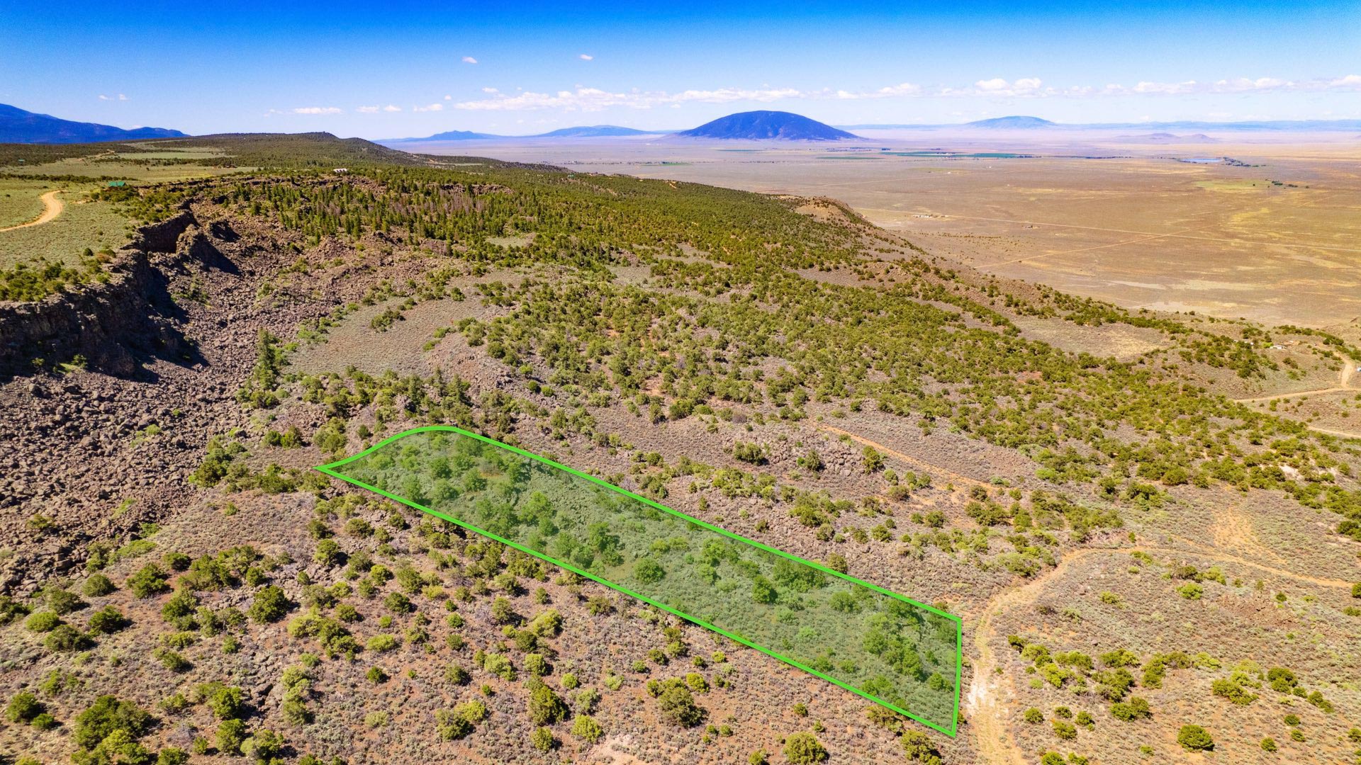
20 Wooded Mountain Acres bordering nearly 300,000 Acres of the Cibola National Forest less than 1 mile from "The Falls" waterfall.
This parcel borders the Cibola National Forest along the West boundary and is covered with dense mature Ponderosa Pines.
There is seasonal water flow running through the entire Eastern portion of the property.
This beautiful forest property offers varying terrain, with the peak elevation on the Western portion near the Cibola National Forest reaching 7,640 feet. This is among one of the highest points in the area, comparable with the 7,700 foot Mesa located 4 miles South.
Bordering the Cibola National Forest comes with opportunity for extended recreation right from the property. The seasonal water flow also offers a source of water for the wildlife residing in the forest. See photos for the many wildlife tracks & droppings found on the property.
Located in Game Management Unit 10, which is said to be desirable for Mule Deer & Elk with some of largest Bulls in New Mexico. (Download the GMU 10 Map)
For more information, visit the New Mexico Game & Fish Department Website.
The richly diverse volcanic landscape of El Malpais National Park offers solitude, recreation, and discovery. Explore cinder cones, lava tube caves, sandstone bluffs, caves and hiking trails. Wildlife abounds in the open grasslands and forests.
The property is 8.7 miles to State Highway 53 which will take you directly to San Rafael to the East, then connects to I-40 to take you into Grants and Milan.
The city of Gallup is located 52 miles from the property. There is a Walmart Supercenter, various parks, professional services, medical centers, groceries, and supplies located here. The population of Gallup, New Mexico is about 21,700.
Grants, New Mexico is also located only 61 miles East, which has a population of around 10,000 people. In Grants you will find groceries, supplies, the Cibola General Hospital, an airport and Walmart Supercenter.
Utility Lines are in the area and on nearby developed properties where land owners have homes, mobile homes, cabins, accessory buildings and corrals (see photos & satellite images).
No HOA, HOA Fees, or time limit to build.
Property Specs
Click the Green BUY NOW Button to place your $499 Deposit. We will receive an instant notification that your $499 deposit has been made. The $499 deposit is credited towards your purchase and we cover ALL of the Closing Costs.
The remaining balance may be paid by Wire Transfer, Cashier’s Check, ACH Bank Draft, Credit Card and/or Debit Card. We also accept Gold, Silver, Platinum, Bitcoin, Ethereum and other Cryptocurrencies. You may also use any combination of these payment methods.
We make the whole process super simple and we can complete your purchase in as little as 1 day.
Purchase Must Be Completed within 10 Calendar Days of the Date the Deposit is placed. A partial refund of $250 may be requested within 5 Calendar Days from the date of the deposit. After the 5th Calendar Day, all cancelled purchases will not be eligible for a refund.
For Questions or to Purchase this Property, Call or Text Us anytime at 866-8-LANDIO (866-852-6346)
Reference LANDIO Property ID: WV_Ritchie_00002
*This Property is presented For Sale By Owner. Seller is a Licensed Real Estate Agent in the State of Texas.
Are You an Agent or Broker in Need of More Exposure for Your Listings? Visit: GOLANDIO.com
Property to Sell? Visit: SELLwithLANDIO.com
Nearby Points of Interest
Bordering the Cibola National Forest (more info)
0.27 mile to Ramah Falls (more info)
8.7 miles to Highway 53
19 miles to El Morro National Monument (more info)
33.1 miles to the El Malpais National Monument (more info)
33.6 miles to the Oso Ridge Lookout (more info)
35.4 miles to the Ice Cave and Bandera Volcano (more info)
52.5 miles to Gallup, New Mexico : Population 21,700 (more info)
56.7 miles to San Rafael, New Mexico : Population 1,000
58.6 miles to the Bluewater State Park (more info)
60 miles to Interstate 40
61 miles to Grants, New Mexico: Population 10,000 (more info)
61.5 miles to Milan, New Mexico : Population 3,200 (more info)
82.5 miles to the Mount Taylor (more info)
137 miles to Albuquerque, New Mexico : Population 556,000 (more info)
Location Information
To Visit This Property, Please Call the Listing Agent Paul Linson at: at: 505-907-1454
The Interactive Maps are generated with MapRight. MapRight has a Free Apple and Android App which can be useful when visiting a property. Below are links to download the Free MapRight App.
Apple (Download App)
Android (Download App)
Interactive Map (View Map)
GPS Coordinates
Northwest Corner: 35.2112301717262, -108.451841649108 (Google Map)
Northeast Corner: 35.2112121367072, -108.447455305649 (Google Map)
Southeast Corner: 35.2095039461638, -108.447431024468 (Google Map)
Southwest Corner: 35.2095218936116, -108.451796661172 (Google Map)
Center Point: 35.210329, -108.449735 (Google Map)
Contact Information
This Property is Listed with New Mexico Real Estate Broker Paul Linson of The Pedroncelli Group Realtors.
If you are interested in Purchasing this Property or any other Property in New Mexico, please contact Paul by Call or Text anytime at: 505-907-1454
Please Reference LANDIO Property ID: NM_Cibola_00066
To Speak with LANDIO, please Call or Text Us Anytime at 866-8-LANDIO (866-852-6346))
Do You Have Property to SELL? Visit at: SELLwithLANDIO.com
Buying Process
Sell Your Property
Questions About This Property?
Contact UsNearby Properties
Texas
TX_Leon_00002

5 Wooded Acres with Utilities & Road Frontage near Houston & Dallas
North Carolina
NC_Caldwell_00001

4.88 Acres with Power, Internet & Road Access near Pisgah National Forest
Tennessee
TN_Stewart_00008

3.2 Wooded Acres with Road Access, Power & High-Speed Fiber Internet
Tennessee
TN_Stewart_00009

2.9 Wooded Acres with Road Access, Power & High-Speed Fiber Internet
Tennessee
TN_Stewart_00010

3 Wooded Acres with Road Access, Power & High-Speed Fiber Internet
New Mexico
NM_Cibola_00071

5.03 Acres with Road Frontage near Cibola National Forest
West Virginia
WV_Ritchie_00001

4.61 Wooded Acres with County Road Frontage
Georgia
GA_Warren_00001

7.59 Wooded Acres with Power & Road Frontage
Tennessee
TN_Stewart_00038

3.5 Wooded Acres with Road Access, Power & High-Speed Fiber Internet
Virginia
VA_Northumberland_00002

2.25 Acres Waterfront Lot that Connects to the Potomac River & Chesapeake Bay
New Mexico
NM_Cibola_00072

20 Acres on top of Mesa with Road Access, Mature Trees & Power Nearby
Virginia
VA_Northumberland_00001
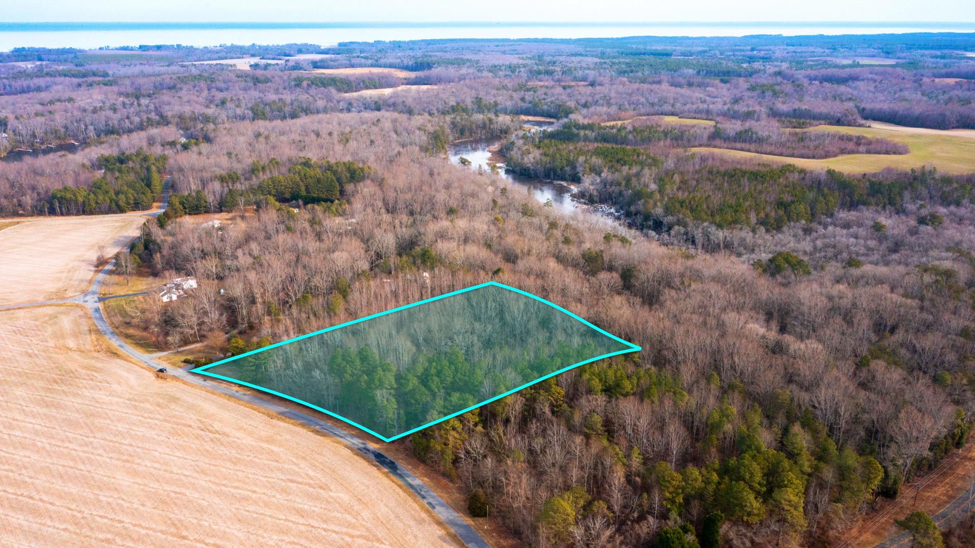
5.5 Acres near the Potomac River & Chesapeake Bay
Wyoming
WY_Carbon_00057

2.05 Acre Lot with Mountain Views near National Forest
Wyoming
WY_Sweetwater_00025

80 Acres bordering 640 Acres of BLM Land around Wild Horses
Arkansas
AR_Chicot_00001
1.94 Acres with Road Frontage & Electricity near the Mississippi River
Wyoming
WY_Natrona_00006

561 Acres bordering BLM Land Overlooking the Alcova Reservoir
New Mexico
NM_Cibola_00074

16 Wooded Mountain Acres near National Forest Land
New Mexico
NM_Lincoln_00004

78 Acre Farm with Water Rights, Power & County Road Frontage
Colorado
CO_Otero_00001

1.38 Acres with 3 Bedroom Home, Workshop & Storefront
New Mexico
NM_Cibola_00040

20 Acres with Private Access to the Cibola National Forest
Colorado
CO_Conejos_00023

433 Acre Riverfront Farm & Ranch with Senior Water Rights & 6 Bedroom Home
Colorado
CO_Las-Animas_00054

35 Wooded Mountain Acres with Electricity & Clearing for Homesite
Wyoming
WY_Sweetwater_00028

120 Acres with Access Bordering BLM Land
New Mexico
NM_Cibola_00066

20 Wooded Mountain Acres Bordering National Forest Land
Colorado
CO_Costilla_00015
2.7 Acres with Mountain Views near Sanchez Reservoir State Wildlife Area
New Mexico
NM_San-Miguel_00002

543 Acres bordering 25,000 Acres of National Forest Land
Utah
UT_Iron_00001

640 Acres bordering BLM Land near Fishlake National Forest
New Mexico
NM_Torrance_00006

10.04 Acres with Power, Internet & Access near National Forest
Montana
MT_Lake_00001

Moiese Valley Ranch | 2,425 Acre Montana Ranch & Dairy Farm
Tennessee
TN_Stewart_00003

4.3 Wooded Acres with Road Access, Power & High-Speed Fiber Internet
Tennessee
TN_Stewart_00004

4.2 Wooded Acres with Road Access, Power & High-Speed Fiber Internet
Tennessee
TN_Stewart_00006

5.2 Wooded Acres with Road Access, Power & High-Speed Fiber Internet
Tennessee
TN_Stewart_00007

4 Wooded Acres with Water Well, Road Access, Power & High-Speed Fiber Internet
Tennessee
TN_Stewart_00017

3.4 Wooded Acres with Road Access, Power & High-Speed Fiber Internet
Tennessee
TN_Stewart_00021
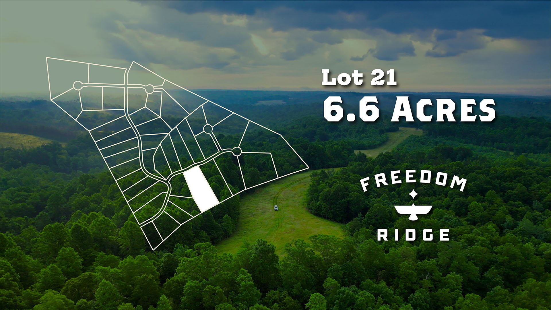
6.6 Wooded Acres with Road Access, Power & High-Speed Fiber Internet
Tennessee
TN_Stewart_00022

5.4 Wooded Acres with Road Access, Power & High-Speed Fiber Internet
Tennessee
TN_Stewart_00023

6.3 Wooded Acres with Road Access, Power & High-Speed Fiber Internet
Tennessee
TN_Stewart_00024

8.5 Wooded Acres near the Cumberland River & Clarksville, TN
Tennessee
TN_Stewart_00025

13.8 Wooded Acres near the Cumberland River & Clarksville, TN
Tennessee
TN_Stewart_00027

3.5 Wooded Acres with Road Access, Power & High-Speed Fiber Internet
Tennessee
TN_Stewart_00028

3 Wooded Acres with Road Access, Power & High-Speed Fiber Internet
Tennessee
TN_Stewart_00030

4.1 Wooded Acres with Water Well, Road Access, Power & High-Speed Fiber Internet
Tennessee
TN_Stewart_00031

3.8 Wooded Acres with Road Access, Power & High-Speed Fiber Internet
Tennessee
TN_Stewart_00032
3.1 Wooded Acres with Road Access, Power & High-Speed Fiber Internet
Tennessee
TN_Stewart_00034

2.4 Wooded Acres with Road Access, Power & High-Speed Fiber Internet
Tennessee
TN_Stewart_00037

2.5 Wooded Acres with Road Access, Power & High-Speed Fiber Internet
Tennessee
TN_Stewart_00040

5.1 Wooded Acres with Road Access, Power & High-Speed Fiber Internet
Tennessee
TN_Stewart_00041

5.4 Wooded Acres with Road Access, Power & High-Speed Fiber Internet
New Mexico
NM_Torrance_00018

10.32 Acre Corner Lot with Power & Internet near National Forest
Utah
UT_Iron_00002

23.52 Acres bordering BLM Land near Fishlake National Forest
Washington
WA_Clark_00002

5 Wooded Acres with Creek, Power & Water near National Forest
Wyoming
WY_Natrona_00005

174 Acres with Creek overlooking the Alcova Reservoir
New York
NY_Putnam_00001

112 Acres across from West Branch Reservoir & Bordering Public Land
Wyoming
WY_Natrona_00004

6 Acres with Road Frontage bordering BLM Land near Alcova Reservoir
California
CA_San-Bernardino_00002

4.37 Acres Surrounded by National Forest near Big Bear Lake
New Mexico
NM_Sandoval_00001

11.49 Acres with Road Frontage, Electricity near BLM Land
California
CA_Inyo_00011

0.87 Acres with Mountain Views near Inyo National Forest
California
CA_Inyo_00010

0.83 Acres with Mountain Views near Inyo National Forest
California
CA_Inyo_00006

0.98 Acres with Mountain Views near Inyo National Forest
California
CA_San-Bernardino_00001

1 Acre with Mountain Views near San Bernardino National Forest
New Mexico
NM_Torrance_00017

10.34 Acres with Power, Internet & Access near National Forest
New Mexico
NM_Torrance_00013

10.03 Acres with Power, Internet & Access near National Forest
New Mexico
NM_Torrance_00007

10.35 Acres with Power, Internet & Access near National Forest
New Mexico
NM_Torrance_00003

10.73 Acres with Power, Internet & Access near National Forest
New Mexico
NM_Torrance_00014


